


Togoland - Picture
More about World War 1
|
|


Togoland
Schutzgebiet Togo
Togoland protectorate
Note: The map uses the borders of the present-day, but the historical extent for German territories are depicted.
Togoland was a German protectorate in West Africa from 1884 to 1914, encompassing what is now the nation of Togo and most of what is now the Volta Region of Ghana. The colony was established during the period generally known as Europeâs imperialist "Scramble for Africa". The German explorer, medical doctor, imperial consul and commissioner for West Africa Gustav Nachtigal was the driving force toward the establishment of the West African colonies of Togoland and Kamerun. From his base on the Spanish island possession Fernando Po in the Bight of Bonny he traveled extensively on the mainland of Africa. On 5 July 1884 Nachtigal signed a treaty with the local chief, Mlapa III, in which he declared a German Empire protectorate over a stretch of territory along the Slave Coast on the Bight of Benin. With the small gunboat SMS Mx¶we at anchor, the imperial flag was raised for the first time on the African continent. Consul Heinrich Ludwig Randad, Jr., resident agent of the firm C. Goedelts at Widah, was appointed as the first commissioner for the territory.
Economics and growth
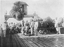
Picture - Loading of cotton bales on the pier at Lome (1885)
Germany gradually extended its control inland. Colonial administrators and settlers brought scientific cultivation to the country's main export crops (cacao, coffee, cotton). The colonyâs infrastructure was developed to one of the highest levels in Africa. Colonial officials built roads and bridges to the interior mountain ranges and three rail lines from the capital Lome; along the coast to Aného in 1905, to Palime (modern Kpalimé) in 1907, and the longest line, the Hinterlandbahn to Atakpamé by 1911.
In 1895 the capital Lome had a population of 31 Germans and 2,084 natives. By 1913 the native population had swelled to 7,042 persons and 194 Germans, including 33 women, while the entire colony had a German population of 316, including 61 women and 14 children. In the years just before the Great War Lome had grown into the âprettiest town in West Africa.â Because it was one of Germany's two self-supporting colonies, Togoland was acknowledged as a small but treasured possession. This would last until the eruption of World War I.
Occupation and beyond
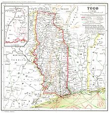
Picture - Map of Togo in 1915.
After calling on the German colony to surrender on 6 August 1914, French and British troops invaded unopposed the next day. No military personnel was stationed in the protectorate. The police force consisted of a commander and deputy commander, 10 German sergeants, 1 native sergeant and 660 Togolese policemen deployed throughout the territory. The Entente forces occupied the capital Lome, then advanced on a powerful and new radio station near Kamina (east of Atakpamé). The colony surrendered on 26 August 1914, after the German technicians who had built the radio installation now destroyed the station during the night of 24/25 August. In the weeks before the destruction, Kamerun, German Southwest Africa, German East Africa and 47 ships on the high seas were sent reports of Allied actions, as well as warnings of predicaments ahead. On 27 December 1916, Togoland was separated into French and British administrative zones. With the ratification of the Treaty of Versailles in 1920, Togoland formally became a League of Nations Class B mandate divided into French Togoland and British Togoland, covering respectively about two-thirds and one-third of the territory.
The British area of the former German colony was integrated into Ghana in 1957 following a May 1956 plebiscite where 58% of British-area residents voted in favour of joining Ghana upon its independence, rather than remaining under British-administered trusteeship. The French-ruled region became the Republic of Togo in 1960 and is now known as the Togolese Republic. In 1960, the new state invited the last German governor of Togoland, Duke Adolf Friedrich of Mecklenburg to the countryâs official independence celebrations.
Footnotes
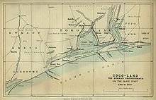
Picture - Map of Togoland in 1885.
List of colonial heads of German Togoland
History of Togo
British Togoland
Volta Region
Gold Coast (British colony)
German West African Company
List of former German colonies
Haupt, Werner (1984). Deutschlands Schutzgebiete in xbersee 1884-1918. [Germanyâs Overseas Protectorates 1884-1918]. Friedberg: Podzun-Pallas Verlag. ISBN 3-7909-0204-7.
Washausen, Helmut (1968). Hamburg und die Kolonialpolitik des Deutschen Reiches. [Hamburg and Colonial Politics of the German Empire]. Hamburg: Hans Christians Verlag.
References in popular culture
In the popular Canadian sketch comedy show, Second City Television (which ran from 1976 to 1984), the news segment skit "SCTV News" regularly included news bulletins about natural catastrophes in "Togoland," though no contemporary country had that name.
In Insomniac Games's video game franchise Resistance series, Britain and France initiated the Great War with an invasion of Togoland.
More aircraft.
Source: WikiPedia