


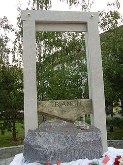
Treaty of Trianon - Picture
More about World War 1
|
|


Treaty of Trianon
: Signing the Treaty on 4 June 1920.
: Signed
Location
: Effective
: Signatories
: Depositary
: Languages
: Treaty of Trianon at Wikisource
1. Principal Allied Powers (Entente)
France
United States
Italy
Japan
United Kingdom
Belgium
Republic of China
Cuba
Czechoslovakia
Greece
Nicaragua
Panama
Poland
Portugal
Romania
Siam
Yugoslavia
2. Kingdom of Hungary, successor of the former Austria-Hungary, the latter was a member of the Central Powers
The Treaty of Trianon was the peace agreement signed in 1920, at the end of World War I, between the Allies of World War I and Hungary (a successor state to Austria-Hungary). The treaty greatly redefined and reduced Hungary's borders. From its borders before World War I, it lost 72% of its territory, which was reduced from 325,111 square kilometres (125,526 sq mi) to 93,073 square kilometres (35,936 sq mi). It also lost 64% of its total population, which was reduced from 20.9 million to 7.6 million, and 31% (3.3 out of 10.7 million) of its ethnic Hungarians, who suddenly found themselves living outside the newly defined borders of Hungary. Hungary lost five of its ten most populous cities and was deprived of direct access to the sea and of some of its most valuable natural resources. The military establishment of the country was reduced to an army of about 35,000, while its navy ceased to exist.
The principal beneficiaries of territorial adjustment were Romania, Czechoslovakia, and the Kingdom of Serbs, Croats and Slovenes. In addition, the newly established state of Hungary had to pay war reparations to its neighbours. The Hungarian delegation signed the treaty under protest on 4 June 1920 at the Grand Trianon Palace in Versailles, France. Hungary recovered part of lost territories in 1938 - 1940 under Third Reich auspices. It was later reduced to boundaries approximating those of 1920 by the peace treaties signed after World War II at Paris, in 1947.
The treaty was registered in League of Nations Treaty Series on August 24, 1921.
Treaty of Trianon internationally guaranteed Hungarian borders.
New borders of Hungary
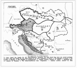
Picture - Drafted borders of Austria-Hungary in the treaty of Trianon and Saint Germain.
The Hungarian government terminated its union with Austria on 31 October 1918, officially dissolving the Austro-Hungarian state. The de facto temporary borders of independent Hungary were defined by the ceasefire lines in November-December 1918. Compared with the former Kingdom of Hungary, these temporary borders did not include:
On 29 October 1918, the Kingdom of Croatia-Slavonia parliament, an autonomous kingdom within the Transleithania, terminated the union with Kingdom of Hungary and on 30 October 1918 Hungarian diet adopted a motion declaring that the constitutional relations between two states have ended. After that Croatia first formed a State of Slovenes, Croats and Serbs with other South Slavic formerly Austro-Hungarian territories on 1 October 1918, then the Kingdom of Serbs, Croats and Slovenes by joining with the Kingdom of Serbia on 1 December 1918.
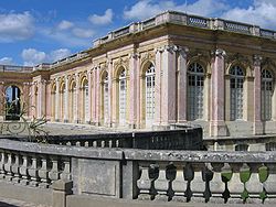
Picture - The Grand Trianon Palace at Versailles is the site of the signing.
Part of Transylvania south of the MureÅ river and east of the SomeÅ river, which came under the control of Romania (cease-fire agreement of Belgrade signed on 13 November 1918). On 1 December 1918, the National Assembly of Romanians in Transylvania declared union with the Kingdom of Romania.After the Romanian Army advanced beyond this cease-fire line, the Entente powers asked Hungary (Vix Note) to acknowledge the new Romanian territory gains by a new line set along the Tisza river. Unable to reject these terms and unwilling to accept them, the leaders of the Hungarian Democratic Republic resigned and the Communists seized power. In spite of the country being under Allied blockade, the Hungarian Soviet Republic was formed and the Hungarian Red Army was rapidly set up. This army was initially successful against the Czechoslovak Legions due to having been implicitly aided with food and weapons by Italy; which made it possible for Hungary to reach nearly the former Galitian (Polish) border, thus separating the Czechoslovak and Romanian troops from each other.
After a Hungarian-Czechoslovak cease-fire signed on 1 July 1919, the Hungarian Red Army left Upper Hungary by 4 July, as the Entente powers promised Hungary to invite a Hungarian delegation to the Versailles Peace Conference. In the end, this particular invitation was not issued. Bela Kun, leader of the Hungarian Soviet Republic, then turned the Hungarian Red Army on the Romanian Army and attacked at the Tisza river on 20 July 1919. After fierce fighting that lasted some five days, the Hungarian Red Army collapsed. The Royal Romanian Army marched into Budapest on 4 August 1919.
The Hungarian state was restored by the Entente powers, helping Admiral Horthy into power in November 1919. On 1 December 1919 the Hungarian delegation was officially invited to the Versailles Peace Conference; however the new borders of Hungary were nearly finalised without the presence of the Hungarians. During prior negotiations, the Hungarian party, along with the Austrian, advocated the American principle of self-determination: that the population of disputed territories should decide by free plebiscite to which country they wished to belong. This view did not prevail for long, as it was overlooked by the decisive French and British delegates. The Allies drafted the outline of the new frontiers with little or no regard to the historical, cultural, ethnic, geographic, economic and strategic aspects of the region. Although the countries that were the main beneficiaries of the treaty partially noted the issues, the Hungarian delegates tried to draw attention to them. Their views were disregarded by the Allied representatives. As a result, problems created by the territorial boundaries contributed to regional destabilisation and the outbreak of World War II.
Most Hungarian settlements, consisting of more than 2 million Magyars, were situated in a typically 20-50 km wide strip along the new borders in foreign territory. More concentrated groups could be found in Czechoslovakia (Upper Hungary), Serbia (Vojvodina or Vajdasx¡g), and Romania (Transylvania).
The final borders of Hungary were defined by the Treaty of Trianon signed on 4 June 1920. Beside exclusion of the previously mentioned territories, they did not include:
the rest of Transylvania, which together with former Eastern Hungary became part of Romania;
Carpathian Ruthenia, which became part of Czechoslovakia, pursuant to the Treaty of Saint-Germain in 1919;
most of Burgenland, which became part of Austria, also pursuant to the Treaty of Saint-Germain; the district of Sopron opted to remain with Hungary after a plebiscite held in December 1921 (it was the only place where a plebiscite was held and factored in the decision); and
MeÄimurje and the 2/3 of the Slovene March or Vendvidék (now Prekmurje), which became part of the Kingdom of Serbs, Croats and Slovenes.
By the Treaty of Trianon, the cities of Pécs, Mohx¡cs, Baja and Szigetvx¡r, which were under Yugoslav administration after November 1918, were assigned to Hungary. An arbitration committee in 1920 assigned small northern parts of the former xrva and Szepes counties of the Kingdom of Hungary with Polish majority population to Poland. After 1918, Hungary did not have access to the sea, which it had formerly had directly through the Rijeka coastline and indirectly through Croatia-Slavonia.
With the help of Nazi Germany and Fascist Italy, Hungary expanded its borders towards neighbouring countries at the outset of World War II. This happened under the Munich Agreement (1938), and the two Vienna Awards (1939 and 1940), following the dissolution of Czechoslovakia (occupation of northern Carpathian Ruthenia and eastern Slovakia) and following the German Invasion of Yugoslavia. This territorial expansion was short-lived, since the post-war Hungarian boundaries agreed on at the Treaty of Paris in 1947 were nearly identical to those of 1920 (with three villages - Jarovce, Rusovce, and Äunovo - transferred to Czechoslovakia).
Rijeka (Croatia)
Consequences
Demographics
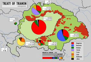
Picture - Difference between the borders of the Kingdom of Hungary within Austria-Hungary and independent Hungary after the Treaty of Trianon. Based on the 1910 census. Administrative Hungary in green, autonomous Croatia-Slavonia grey.
According to the census of 1910, the largest ethnic group in the Kingdom of Hungary were the Hungarians, who were approximately 48% of the entire population (or 54% of the population of the territory referred to as "Hungary proper", i.e., excluding Croatia-Slavonia). The Kingdom of Hungary was not a nation-state as were many Western European nations.
Some demographers believe that the 1910 census exaggerated the percentage of the Hungarian population, pointing to the discrepancy between an improbably high growth of the number of Hungarians and the decrease of other nationalities due to magyarization in the kingdom in the late 19th century. They also argue that there were different results in previous censuses of the Kingdom and subsequent censuses in the new states. Another problem with interpreting the census results is that the 1910 census did not record the respondents' ethnicity, but only language (whether it was "native language" or "most frequently spoken language") and the religion, thus the presented census numbers of ethnic groups in the Kingdom of Hungary are actually the numbers of speakers of various languages, which may not correspond exactly to the ethnic composition.
![World War 1 Picture - The Red Map.[22][23] Ethnic map of the Hungary proper publicised by the Hungarian delegation. Regions with population density below 20 persons/km2[24] are left blank and the corresponding population is represented in the nearest region with population density above that limit. Hungarians, Germans, Slovaks, Rusyns, Romanians, Croats, Spaces with a smaller density than 20 persons/sq km](./images/1-images52211/300px-Ethnographic_map_of_hungary_1910_by_teleki_carte_rouge.jpg)
Picture - The Red Map.[22][23] Ethnic map of the Hungary proper publicised by the Hungarian delegation. Regions with population density below 20 persons/km2[24] are left blank and the corresponding population is represented in the nearest region with population density above that limit. Hungarians, Germans, Slovaks, Rusyns, Romanians, Croats, Spaces with a smaller density than 20 persons/sq km
Although the territories of the former Kingdom of Hungary that were assigned by the treaty to neighbouring states in total had a majority of non-Hungarian population, they also included areas of Hungarian majority (even areas over 80-90% Hungarians) and significant Hungarian minorities, numbering 3,318,000 in total. After the treaty, the percentage and the absolute number of all Hungarian nationalities decreased in the next decades. The main reasons of this process were spontaneous assimilation and Slovakization, Romanianization, Serbianisation policy of the states. After World War II, the Czechoslovak government with the Bene decrees granted the forcible "population transfer" (deportation) in 1945-47 of about 2.6 million former Czechoslovak citizens of German and Hungarian ethnicity to Germany, Austria and Hungary.
Distribution of the Hungarian population in the Kingdom of Hungary
The number of Hungarians in the different areas based on census data of 1910. The present day location of each area is given in parenthesis.
In Upper Hungary (Slovakia): 885,000 - 30%
In Transylvania (Romania): 1,662,948 - 31.6%
In Vojvodina (Serbia): 420,000 - 28%
In Transcarpathia (Ukraine): 183,000 - 30%
In Croatia: 121,000 - 3.5%
In Slovene March (today Prekmurje, Slovenia): 14,065 - 15%
In Burgenland (Austria): 26,200 - 9%
Distribution of the non-Hungarian population in the Kingdom of Hungary
Slovaks, Romanians, Ruthenians, Serbs, Croats and Germans, who represented the majority of the populations of the above-mentioned territories based on 1910 census data:
In Upper Hungary (Slovakia, Czechoslovakia): 1,687,977 Slovaks and 1,233,454 others (mostly Hungarians - 886,044, Germans, Ruthenians and Roma) [according to the 1921 census, however, there were 1,941,942 Slovaks and 1,058,928 others]
In Carpathian Ruthenia (Czechoslovakia): 330,010 Ruthenians and 275,932 others (mostly Hungarians, Germans, Romanians, and Slovaks)
In Transylvania (Romania): 2,831,222 Romanians (53.8%) and 2,431,273 others (mostly Hungarians - 1,662,948 (31.6%) and Germans - 563,087 (10.7%)). The 1919 and 1920 Transylvanian censuses indicate a greater percentage of Romanians (57.1%/57.3%) and a smaller Hungarian minority (26.5%/25.5%)
In Vojvodina and Croatia-Slavonia (Yugoslavia): 2,756,000 Croats and Serbs and 1,366,000 others (mostly Hungarians and Germans)
In Slovene March (today Prekmurje, Slovenia): 74,199 Slovenes (80%), 14,065 Hungarians (15,2%), 2,540 Germans (2,7%)
In Burgenland (Austria): 217,072 Germans and 69,858 others (mainly Croatian and Hungarian)
Minorities in post-Trianon Hungary
On the other hand, a considerable number of other nationalities remained within the frontiers of the new Hungary:
According to the 1920 census 10.4% of the population spoke one of the minority languages as mother language:
551,212 German (6.9%)
141,882 Slovak (1.8%)
23,760 Romanian (0.3%)
36,858 Croatian (0.5%)
23,228 Bunjevac and Å okac (0.3%)
17,131 Serb (0.2%)
7,000 Slovenes (0,08%)
The number of bilingual people was much higher, for example 1,398,729 people spoke German (17%), 399,176 people spoke Slovak (5%), 179,928 people spoke Croatian (2.2%) and 88,828 people spoke Romanian (1.1%). Hungarian was spoken by 96% of the total population and was the mother language of 89% of the people.
The percentage and the absolute number of all non-Hungarian nationalities decreased in the next decades, although the total population of the country increased. Bilingualism was also disappearing. The main reasons of this process were both spontaneous assimilation and the deliberate Magyarization policy of the state. Minorities made up 8% of the total population in 1930 and 7% in 1941 (on the post-Trianon territory).
After World War II approximately 200,000 Germans were deported to Germany, according to the decree of the Potsdam Conference. Under the forced exchange of population between Czechoslovakia and Hungary, approximately 73,000 Slovaks left Hungary. After these population movements Hungary became an almost ethnically homogeneous country except for the rapidly growing number of Roma people in the second half of the 20th century.
Political consequences

Picture - Bordermark on the Hungarian-Romanian border near Csenger.
Officially the treaty was intended to be a confirmation of the right of self-determination for nations and of the concept of nation-states replacing the old multinational Austro-Hungarian empire. Although the treaty addressed some nationality issues, it also sparked new ones. While many ethnic groups in the Kingdom of Hungary, such as Slovaks, Romanians, Serbs and Croats, established or joined their nation-states, as many as a third of the Hungarian population lived in these annexed territories. As a result, a significant portion of ethnic Hungarians, lived outside the borders of the new Hungary.
So, while the areas that had been detached from Hungary had non-Hungarian majorities overall, there were also large areas with a majority of Hungarians, mostly near the newly created border. There have periodically been concerns about the treatment of these ethnic Hungarian communities in the neighbouring states. Areas with significant Hungarian populations included the Székely Land in Eastern Transylvania, the area along the new Romanian-Hungarian border (cities of Arad, Oradea), the area north of the new Czechoslovakian-Hungarian border (Komx¡rno, Csallx³kx¶z), southern parts of Subcarpathia and northern parts of Vojvodina.
The Allies rejected the idea of plebiscites in the disputed areas with the exception of the city of Sopron, which voted to remain in Hungary. The Allies were indifferent as to the exact line of the new border between Austria and Hungary. Furthermore, ethnically diverse Transylvania, with an overall Romanian majority (53.8% - 1910 census data or 57.1% - 1919 census data or 57.3% - 1920 census data), was treated as a single entity at the peace negotiations and was assigned in its entirety to Romania. The option of partition along ethnic lines as an alternative was rejected.
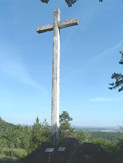
Picture - The Trianon cross at KÅszeg is pointing onto the lost territories.
Another reason why the victorious Allies decided to dissolve the Central-European superpower, Austria-Hungary, a strong German supporter and fast developing region, was to prevent Germany from acquiring substantial influence in the future. The Western powers' main priority was to prevent a resurgence of the German Reich and they therefore decided that her allies in the region, Austria and Hungary, should be "contained" by a ring of states friendly to the Allies, each of which would be bigger than either Austria or Hungary. Compared to the Habsburg Kingdom of Hungary, post-Trianon Hungary had 60% less population and its political and economic footprint in the region was significantly reduced. Hungary lost strategic military and economic infrastructure due to the concentric layout of the railway and road network which the borders bisected. In addition, the structure of its economy collapsed, because it had relied on other parts of the Kingdom. The country also lost access to the Mediterranean, having lost the important sea port of Rijeka (Fiume), and became landlocked, which had a negative effect on sea trading and strategic naval operations. Furthermore, many trading routes that went through the new borders from various parts of the old kingdom were abandoned.
With regard to the ethnic issues, the Western powers were aware of the problem posed by the presence of so many Hungarians (and Germans) living outside the new nation-states of Hungary and Austria. The Romanian delegation to Versailles feared in 1919 that the Allies were beginning to favour the partition of Transylvania along ethnic lines to reduce the potential exodus and Prime Minister Ion I. C. BrÄtianu even summoned British-born Queen Marie to France to strengthen their case. The Romanians claimed that they had suffered a higher relative casualty rate in the war than either Britain or France and that the Western powers had a moral debt to repay. In absolute terms, Romanian troops had considerably fewer casualties than either Britain or France, however. The underlying reason for the decision was a secret pact between The Entente and Romania. In the Treaty of Bucharest (1916) Romania was promised Transylvania and territories to the east of river Tisza, provided that she attacked Austria-Hungary from the south-east, where defences were weak. However, after the Central Powers had noticed the military manoeuvre, the attempt was quickly choked off and Bucharest fell in the same year.
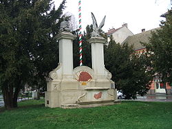
Picture - Trianon memorial, Békéscsaba.
By the time the victorious Allies arrived in France, the treaty was already settled, which made the outcome inevitable. At the heart of the dispute lay fundamentally different views on the nature of the Hungarian presence in the disputed territories. For Hungarians, the outer territories were not seen as colonial territories, but rather part of the core national territory. The western powers and most non-Hungarians that lived in the Carpathian Basin saw the Hungarians as colonial-style rulers who had oppressed the Slavs and Romanians since 1848, when they introduced laws that the language used in education and in local offices was to be Hungarian. For non-Hungarians from the Carpathian Basin it was a process of decolonisation rather than a punitive dismemberment. The Hungarians did not see it this way because the borders were not ethnically correct, with areas where there were Hungarian majorities outside the new borders. The French sided with their allies the Romanians who had a long policy of cultural ties to France since the country broke from the Ottoman Empire (due in part to the relative ease at which Romanians could learn French) although Clemenceau personally detested Bratianu. President Wilson initially supported the outline of a more ethnically correct border based on the Coolidge Report, led by Harvard Professor A. C. Coolidge, but later gave in, due to changing international politics and as a courtesy to other allies.
For Hungarian public opinion, the realisation of the loss of most of the country's territory and significant numbers of ethnic Hungarians was followed by a lingering bitterness because they would have preferred to maintain the integrity of the territory for mainly economic and strategic reasons, and claimed that they were ready to give the minorities a great deal of autonomy. Indeed, most Hungarians regarded the treaty as an insult to the nation's honour. The Hungarian attitude towards Trianon was summed up in the phrases Nem, nem, soha! ("No, no, never!") and Mindent vissza! ("Return everything!" or "Everything back!") The perceived humiliation of the treaty became a dominant theme in inter-war Hungarian politics, analogous with the German reaction to the Treaty of Versailles. The outcome of the Treaty of Trianon is to this day remembered in Hungary as the Trianon trauma. All official flags in Hungary were lowered until 1938, when they were raised by one-third after southern Slovakia, with an 84% Hungarian population (i.e. 550,000 Hungarians) was "recovered" following the Munich Conference. The Hungarian irredentism fuelled not only the revisionist inter-war Hungarian foreign policy but became a source of regional tension after the Cold War too.
Economic consequences
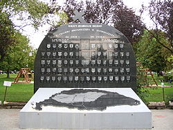
Picture - Trianon memorial, Kiskunhalas.
The Austro-Hungarian Empire was one economic unit with autarkic characteristics during its golden age and therefore achieved rapid growth, especially in the early 20th century when GNP grew by 1.76%. (That level of growth compared very favourably to that of other European nations such as Britain (1.00%), France (1.06%), and Germany (1.51%).) There was also a division of labour present throughout the empire: that is, in the Austrian Empire manufacturing industries were highly advanced, while in the Kingdom of Hungary an agroindustrial economy had emerged. By the late 19th century economic growth of the eastern regions consistently surpassed that of western, thus discrepancies eventually began to diminish. The key success of fast development was specialisation of each region in fields that they were best.
Hungary was the main supplier of wheat, rye, barley and other various goods in the empire and these comprised a large portion of the empire's exports. Meanwhile, the Czech Republic (Kingdom of Bohemia) owned 75% of the whole industrial capacity of formal Austria-Hungary. This clearly shows that the various parts of the formal monarchy were economically interdependent. To further illustrate this point, post-Trianon Hungary produced 500% more agricultural goods than it needed for itself and mills around Budapest were one of the largest ones in Europe at the time; now forced to operate at 20% level. As a consequence of the treaty, all the competitive industries of the formal empire were compelled to close doors, as great capacity was met by negligible demand owing to economic barriers presented in the form of the new borders.
Furthermore, post-Trianon Hungary possessed 90% of the engineering and printing industry of the Kingdom, while only 11% of timber and 16% iron was retained. In addition, 61% of arable land, 74% of public road, 65% of canals, 62% of railroads, 64% of hard surface roads, 83% of pig iron output, 55% of industrial plants, 100% of gold, silver, copper, mercury and salt mines, and most of all, 67% of credit and banking institutions of the former Kingdom of Hungary lay within the territory of Hungary's neighbours. New borders also bisected transport links - in the Kingdom of Hungary the road and railway network had a radial structure, with Budapest in the centre. Many roads and railways, running along the new borders and interlinking radial transport lines, ended up in different, highly introvert countries. Hence, much of the rail cargo traffic of the emergent states was virtually paralysed. These factors all combined created staggering imbalances in the artificially separated, core economic regions of the formal Monarchy.

Picture - Professor A. C. Coolidge.
The disseminating economic chaos had been also noted in the Coolidge Report as a very serious potential aftermath of the treaty. In spite of this fact, the warning was not taken into account during the negotiations. Thus, the resulting uneasiness and despondency of the concerned population was later one of the main antecedents of World War II. Unemployment levels in Austria, as well as in Hungary, were dangerously high, and industrial output dropped by 65%. What happened to Austria in industry happened to Hungary in agriculture where production of grain declined by more than 70%. Austria, especially the imperial capital Vienna, was a leading investor of development projects throughout the empire with more than 2.2 billion crown capital. This sum sunk to a mere 8.6 million crowns after the treaty took effect and resulted in a starving of capital in other regions of the former empire.
The disintegration of the multi-national state conversely impacted neighbouring countries, too: In Poland, Romania, Yugoslavia, and Bulgaria a fifth to a third of the rural population could find no work, and industry was in no position to absorb them.
In comparison, by 1921 the new Czechoslovak state reached 75% of its pre war production owing to their favourable position among the victors, thus greater access to international rehabilitation resources.
With the creation of customs barriers and fragmented protective economies, the economic growth and outlook in the region sharply declined; which in the end culminated in a deep recession. It proved to be immensely challenging for the successor states to successfully transform their economies to adapt to the new circumstances. All the formal districts of Austria-Hungary used to rely on each other's exports for growth and welfare; by contrast, 5 years after the treaty, traffic of goods between the countries dropped to less than 5% of its former value. This could be put down to the introduction of aggressive nationalistic policies by local political leaders.
The drastic shift in economic climate forced the countries to re-evaluate their situation and to promote industries where they had fallen short. Austria and Czechoslovakia subsidised the mill, sugar and brewing industries, Hungary attempted to increase the efficiency of iron, steel, glass and chemical industries. The stated objective was that all countries should become self sufficient. This tendency, however, lead to uniform economies and competitive economic advantage of long well-established industries and research fields evaporated. The lack of specialisation adversely affected the whole Danube-Carpathian region caused a distinct setback of growth and development compared to the West as well as high financial vulnerability and instability.
Miscellaneous consequences
Picture - Memorial in Csx¡talja
Romania, Yugoslavia and Czechoslovakia had to assume part of the financial obligations of the former Kingdom of Hungary on account of the parts of its territory under their sovereignty.
Conditions were similar to those imposed on Germany by the Treaty of Versailles. After the war, the Hungarian navy, air force and army was disbanded. The army was to be restricted to 35,000 men and there was to be no conscription. Heavy artillery, tanks and air force were prohibited to maintain. Further provisions stated that in Hungary, no railway would be built with more than one track (even going so far as to remove one of the two tracks on one of the lines), due to the fact that at that time railways held a substantial strategical importance economically as well as military.
Hungary also renounced all privileges in territories outside Europe that belonged to the former Austro-Hungarian monarchy.
Articles 54-60 of the Treaty required Hungary to recognise various rights of national minorities within its borders.
Articles 61-66 stated that all former citizens of the Kingdom of Hungary living outside the new frontiers of Hungary were to ipso facto lose their Hungarian nationality in one year.
Treaty of Versailles
Treaty of Saint-Germain-en-Laye
History of Hungary
History of Romania
History of Slovakia
History of Transylvania
History of Vojvodina
History of Croatia
History of Slovenia
Banat Republic
Hungarian Soviet Republic
Republic of Prekmurje
Serbian-Hungarian Baranya-Baja Republic
Slovak Soviet Republic
Further reading
Dupcsik Csaba-Répx¡rszky Ildikx³ (2006). Tx¶rténelem IV kx¶zépiskolx¡sok szx¡mx¡ra. Műszaki Kiadx³ (Wolters Kluwer csoport). ISBN 963 16 2945 7
Lingering effects of the Treaty on the geo-politics of Hungary and the successor states
Ernest A. Rockwell: Trianon Politics, 1994-1995, thesis, Central Missouri State University, 1995.
Minorities in post-Trianon Hungary literature
Jx³zsef Kovacsics: Magyarorszx¡g tx¶rténeti demogrx¡fix¡ja : Magyarorszx¡g népessége a honfoglalx¡stx³l 1949-ig, Budapest : Kx¶zgazd. és Jogi Kiadx³ ; 1963 Budapest Kossuth Ny.
Lajos Thirring: Az 1869-1980. évi népszx¡mlx¡lx¡sok tx¶rténete és jellemzÅi [kész. a Kx¶zponti Statisztikai Hivatal Népesedésstatisztikai FÅosztx¡lyx¡n], Bp. : SKV, 1983
Events preceding the Treaty and for minorities in the post-Trianon successor states
ErnÅ Raffay: Magyar tragédia: Trianon 75 éve. Px¼ski kiadx³ (1996)
Vitéz Kx¡roly Kollx¡nyi: Kx¡rpx¡ti trilx³gia. Krx¡ter Műhely Egyesx¼let (2002)
Macartney, Carlile Aylmer October Fifteenth - A History of Modern Hungary 1929-1945. Edinburgh University Press (1956)
Juhx¡sz Gyula: Magyarorszx¡g Kx¼lpolitikx¡ja 1919-1945. Kossuth Kx¶nyvkiado, Budapest (1969).
General H.H. Bandholtz: "An Undiplomatic Diary". Columbia University (1933)
More aircraft.
Source: WikiPedia